Comma2k19数据集使用

需用bittorrent下载,ubuntu用默认的工具下载即可,之后就是漫长的等待。
|
+-- route_id (dongle_id|start_time)
|
+-- segment_number
|
+-- preview.png (first frame video)
+-- raw_log.bz2 (raw capnp log, can be read with openpilot-tools: logreader)
+-- video.hevc (video file, can be read with openpilot-tools: framereader)
+-- processed_log/ (processed logs as numpy arrays, see format for details)
+-- global_pos/ (global poses of camera as numpy arrays, see format for details)
processed_log文件夹中的每个日志类型都包含2个numpy数组,分别是使用系统设备引导时间的时间戳数组(以秒为单位)和值数组。
|
+--IMU ([forward, right, down])
| |
| +--acceleration: (m^2/s)
| +--gyro_uncalibrated (rad/s)
| +--gyro_bias: android gyro bias estimate (rad/s)
| +--gyro: with android bias correction (rad/s)
| +--magnetic_uncalibrated: (T)
| +--magnetic: with android calibration(T)
|
+--CAN data:
| |
| +--car_speed (m/s)
| +--steering_angle (deg)
| +--wheel_speeds: [front_left, front_right, rear_left, rear_right] (m/s)
| +--radar: [forward distance (m),
| | left distance (m),
| | relative speed (m/s),
| | nan,
| | nan,
| | address,
| | new_track (bool)]
| +--raw CAN: This not stored as a value array but as three seperate arrays [src, address, data]
|
+--GNSS
|
+--live_gnss_qcom: [latitude (deg),
| longitude (deg),
| speed (m/s),
| utc_timestamp (s),
| altitude (m),
| bearing (deg)]
+--live_gnss_ublox: [latitude (deg),
| longitude (deg),
| speed (m/s),
| utc_timestamp (s),
| altitude (m),
| bearing (deg)]
|
+--raw_gnss_qcom: every row represents a measurement
| of 1 sattelite at 1 epoch can easily
| be manipulated with laika.
| [prn (nmea_id, see laika),
| week of gps_time of reception (gps_week),
| time pf week of gps_time of reception (s),
| nan,
| pseudorange (m),
| pseudorange_std (m),
| pseudorange_rate (m/s),
| pseudorange_rate_std (m/s)]
+--raw_gnss_ublox: every row represents a measurement
of 1 sattelite at 1 epoch can easily
be manipulated with laika.
[prn (nmea_id, see laika),
week of gps_time of reception (gps_week),
time pf week of gps_time of reception (s),
GLONASS channel number (-7..6) nan if not GLONASS,
pseudorange (m),
pseudorange_std (m),
pseudorange_rate (m/s),
pseudorange_rate_std (m/s)]
raw表示未经处理,live表示可以直接使用。所有的日志都是由raw_log.bz2用openpilot(是项目的一个子模块)读取处理出来的。
frame_gps_times: timestamps of video frames in gps_time: ([gps week (weeks), time-of-week (s)])
frame_positions: global positions in ECEF of camera(m)
frame_velocities: global velocity in ECEF of camera (m/s)
frame_orientations: global orientations as quaternion needed to
rotate from ECEF frame to local camera frame
defined as [forward, right, down] (hamilton quaternion!!!!)
comma2k19中的全局位置以米为单位在ECEF中给出,并且方向被给出为从ECEF旋转到本地框架所需的四元数。其中根据NED[North, East, Down]惯例,本地框架被定义为[向前、向右、向下]。
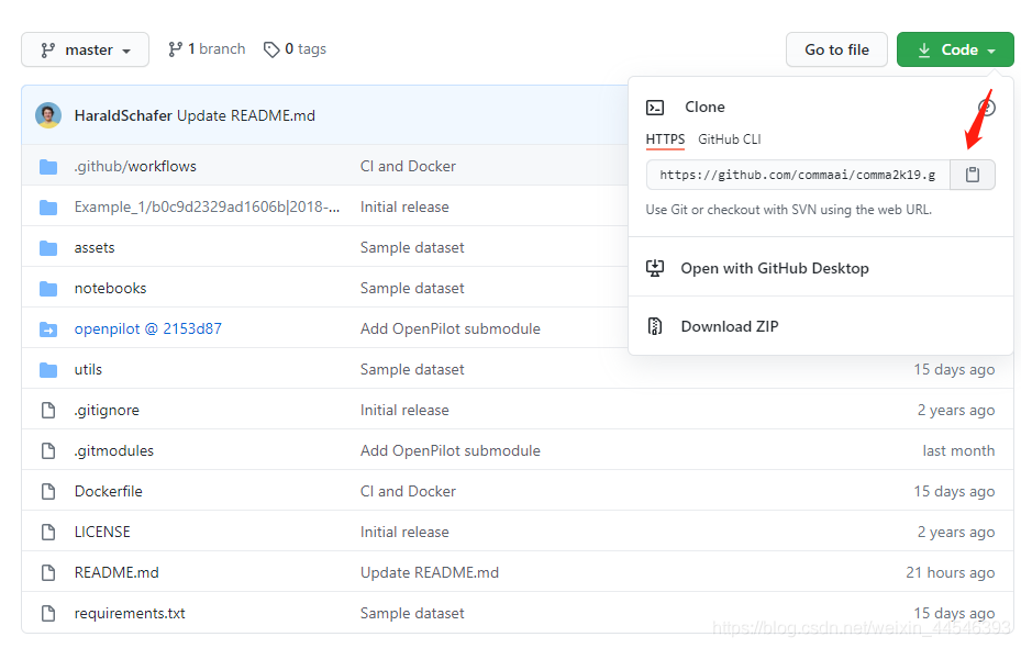
你想要放置的地方打开终端,输入git命令,如果没有安装git的需要安装一下,安装教程。此处会遇到第一个坑,直接终端执行命令git clone [url]会发现openpilot文件夹下是空的。这是因为openpilot它在原项目中的图标带了一个白色箭头,类似于引用,用普通的clone命令将其拷贝下来。因此在终端运行命令git clone --recurse-submodules [url]来递归下载所有引用子模块。
windows系统用户注意:如果你最终是要在windows系统下做实验,那么你需要把下载好的数据集解压到windows的文件系统中,因为我是装的双系统,所以在ubuntu的文件系统中可以访问到windows的文件系统。终端运行 python3 utils/unzip_msft_fs.py 去将文件解压到windows文件系统,其中 是你在unbuntu下下载压缩数据集的文件夹, 是你的目标文件夹,这个命令需要执行很长时间,它会并行解压所有的压缩包并将“|”以下划线“_”代替,请保证目标文件夹磁盘有足够的空间并耐心等待。
 ipynb的文件可以在anaconda的jupyter上打开浏览。
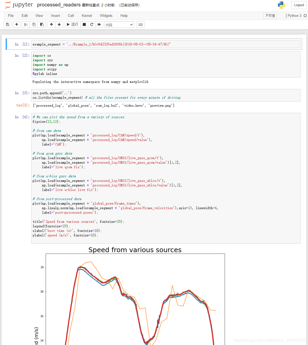
processed_readers: 读取数据并绘图的示例 position_benchmarks: 运行定位基准的示例,定位基准用于评估定位质量 raw_readers: 使用OpenPilot tools的示例 与GNSS原始数据相关的示例请访问Laika

这是由于安装pycurl失败 进入下载地址https://www.lfd.uci.edu/~gohlke/pythonlibs/安装ctrl+f搜索pycurl,下载对应的版本的pycurl
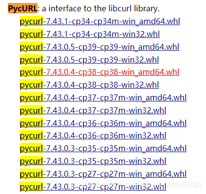
cp36意思是CPython version 3.6.,win_amd64意思是64位的windows操作系统,按照你自己的配置选择对应的安装包下载。然后到本地切换到pycurl的下载位置,运行pip3 install [pycurl]安装。

之后你可以在pycharm上打开该项目文件夹,注意一定要添加openpilot和notebooks到PYTHONPATH中。添加方式:file->setting->interpreter

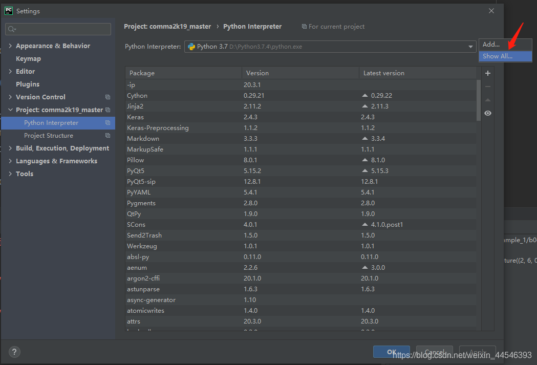


这样在import组件的时候就会去这些路径下查找了。做完上述准备工作后我们就可以运行一下utils下的代码了,注意在代码中把文件名中的“|”改成“_”,且注意当前工作位置。下次将介绍如何使用该数据集实现具体的项目。
编辑推荐
最新资讯
-
自动驾驶卡车创企Kodiak 将通过SPAC方式上
2025-04-19 20:36
-
编队行驶卡车仍在奔跑
2025-04-19 20:29
-
全国汽车标准化技术委员会汽车节能分技术委
2025-04-18 17:34
-
我国联合牵头由DC/DC变换器供电的低压电气
2025-04-18 17:33
-
中国汽研牵头的首个ITU-T国际标准正式立项
2025-04-18 17:32


 广告
广告


